

INTRODUCTION
The genus Gueldenstaedtia Fisch., is small genus of Fabaceae including only four species worldwide (Zhu, 2004; Plants of the World Online, 2021). This genus ranges from the Sino-Himalayan region to Mongolia and Siberia (Lock and Schrire, 2005). Gueldenstaedtia formerly belonged to the Galegeae subtribe (Zhu, 2004), but more recently has been transferred to subtribe Chesneyinae based on extensive molecular studies (Duan et al., 2016). In the past, Zhu (2004) revised the genus, including the global distribution, illustration, taxonomic notes, and nomenclature. Furthermore, the pollen and seed morphology of this genus were characterized by Zhu (2005). In general, Gueldenstaedtia is characterized by perennial herbs, tick and woody roots, and flower purple, pink or yellow (Zhu, 2004). This genus is very similar to genus Tibetia (Ali) H. P. Tsui but several morphological characters differ from Tibetia by its two upper calyx free, and stipules free and adnate as well as pollen grains 3-colporate, psilate, and spheroidal (Zhu, 2004, 2005).
Two species of Gueldenstaedtia are currently distributed in Mongolia: G. monophylla Fisch and G. verna (Georgi) Boriss. (Yakovlev, 1980, 2003; Grubov 1982; Baasanmunkh et al., 2022a). G. monophylla occurs in southern and western Mongolia (Oyuntsetseg et al., 2017), while G. verna is distributed in the eastern part of the country (Yakovlev, 1980, 2003; Grubov, 1982). Despite its presence, there are no detailed wild photographs or newly collected materials of G. verna in Mongolia. Only a small number of herbarium specimens of G. verna collected in Mongolia exist, stored at the Moscow Herbarium (MW) and gathered before 1990. In addition, this species was found in the Khuvsgul region (Doronkin et al., 2015). Moreover, several floristic studies from eastern Mongolia have been published in recent decades but G. verna has was not documented in these efforts (Neuffer et al., 2012; Shagdar and Yadamsuren 2017; Baasanmunkh et al., 2019). Here we present our findings of G. verna from our recent field surveys in eastern Mongolia in 2020.
MATERIALS AND METHODS
Since 2016, we have been actively conducting field surveys in Mongolia to collect fresh vascular plants from the diverse vegetation types and document species occurrence data. During the field surveys, we found two species of Gueldenstaedtia from the western and eastern parts of the country. Detailed photographs of each species were taken during the field surveys by authors. In addition, we examined the herbarium specimens from several herbaria ALTB, MW, LE, NS, NSK, and UBU (Thiers, 2020) in order to make description and distribution map. Grid distribution maps of each species were produced in ArcGis, using the same approach as Baasanmunkh et al. (2021, 2022b).
The regional conservation assessments were based on IUCN (International Union for Conservation of Nature and Natural Resources) criterion B (including sub-criteria B1; the extent of occurrence, EOO, and B2; the area of occupancy, AOO) which uses geographic range size and evidence of declining or fragmented populations (International Union for Conservation of Nature and Natural Resources, 2019). The EOO and AOO were estimated using the ConR package (Dauby et al., 2017) in R 4.0.3. (R Core Team, 2016). The minimum AOO was calculated based on a user-defined grid cell of 2 km2, followed by the International Union for Conservation of Nature and Natural Resources (2019).
TAXONOMIC TREATMENT
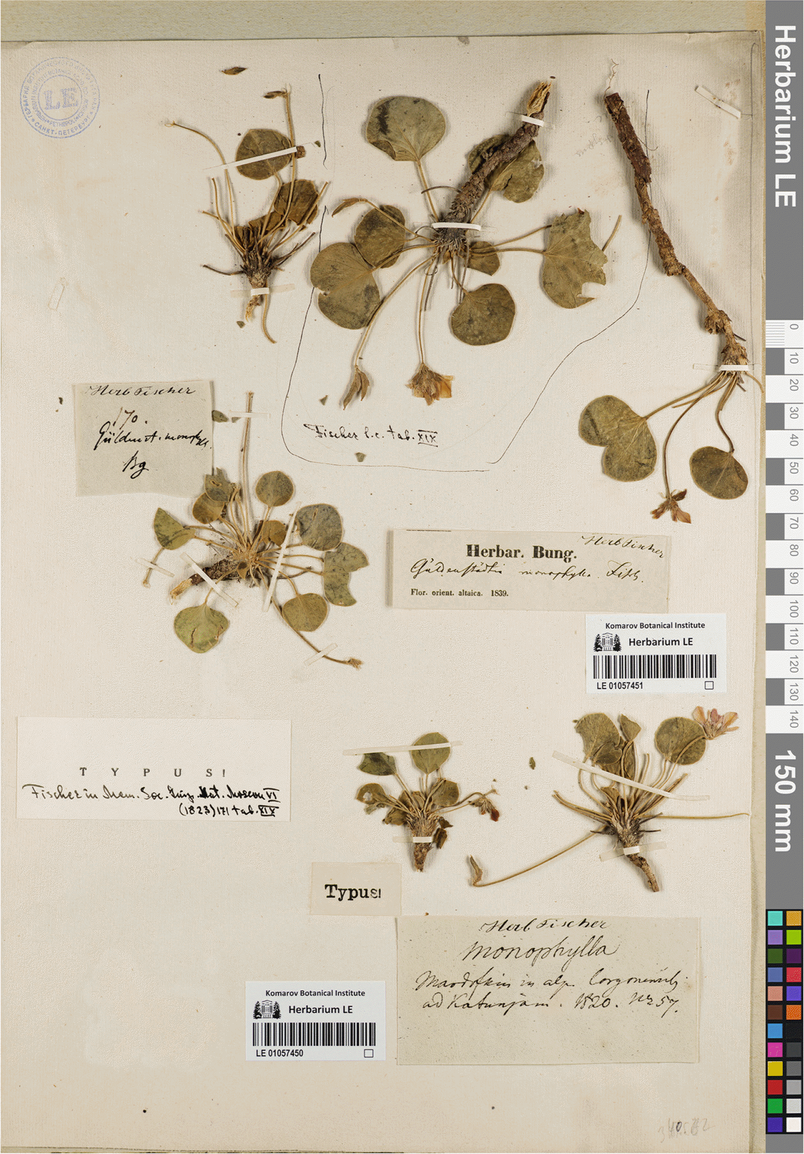
Gueldenstaedtia monophylla Fisch, Mém. Soc. Imp. Naturalistes Moscou 6: 171, 1823 (Figs. 1–3).––TYPE: RUSSIA. In Alp. Corgonensis ad Katunjam. Coll. Mordofkin, 1820. n. 57 (lectotype: designated by Yakovlev (1980), LE01057450, photo (Fig. 3)!; isolectotype LE01057452, photo!).
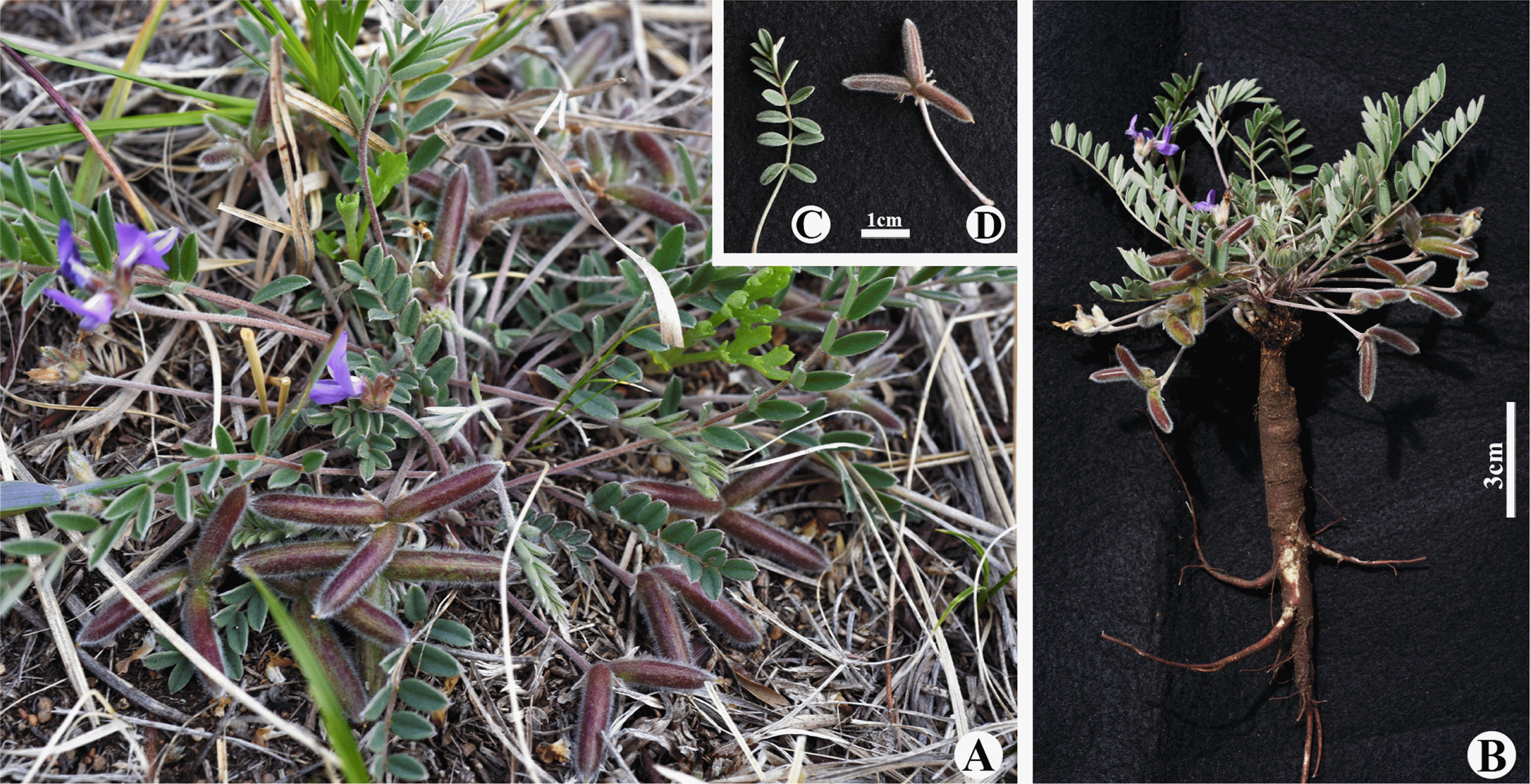
Perennial herb, 5–18 cm tall. Stem short. Leaf solitary, rarely 2- or 3-lobed; leaflets round, reniform, or orbicular, broad or sometimes slightly notched at base, obtuse to short-pointed at apex, sometimes 2- or 3-lobed, with appressed sericeous hairs, 1–3.5 cm long, 1.5–4.5 cm wide. Stipules lanceolate, 3–5 cm long, with appressed hairs, ciliate, connate at base; leaves with hairs, petiole 2–6 cm long; peduncles numerous, slender, sericeous, 3–13 cm long; racemes with 2–6 flowers, pedicels 1–2 mm long, or subsessile; bracts filiform, 2–5 mm long, bracteoles filiform, shorter than calyx tube; calyx broadly campanulate, sericeous, 5-mm long, 5-lobed, teeth lanceolate, 2/3 of tube; corolla violet; standard broadly obovate, entire or slightly emarginated at apex, 12–14 mm long, claw broad and short; wings 10–12 mm long, as long as standard, oblong, obtuse at apex, claw 1–1.5 mm long; keel-petals ca. 4 mm long, whitish, lamina incurved, as long as filiform claw; stamens diadelphous (9 + 1), shorter than keel-petals; ovary oblong, hairy; style curved, glabrous, ca. 1 mm long, 3.5–5 mm wide, appressed-pubescent. Seeds renifrom, irregularly circle reticulate.
Flowering and fruiting: May to August.
Distribution: Mongolia (Khovd, Mongolian Altai, Depression of Great Lakes, East Gobi, Trans-Altai Gobi, Alashan Gobi) and Russia (Altai, Tuva) (Yakovlev, 1980, 2003; Zhu, 2004; Plants of the World Online, 2022).
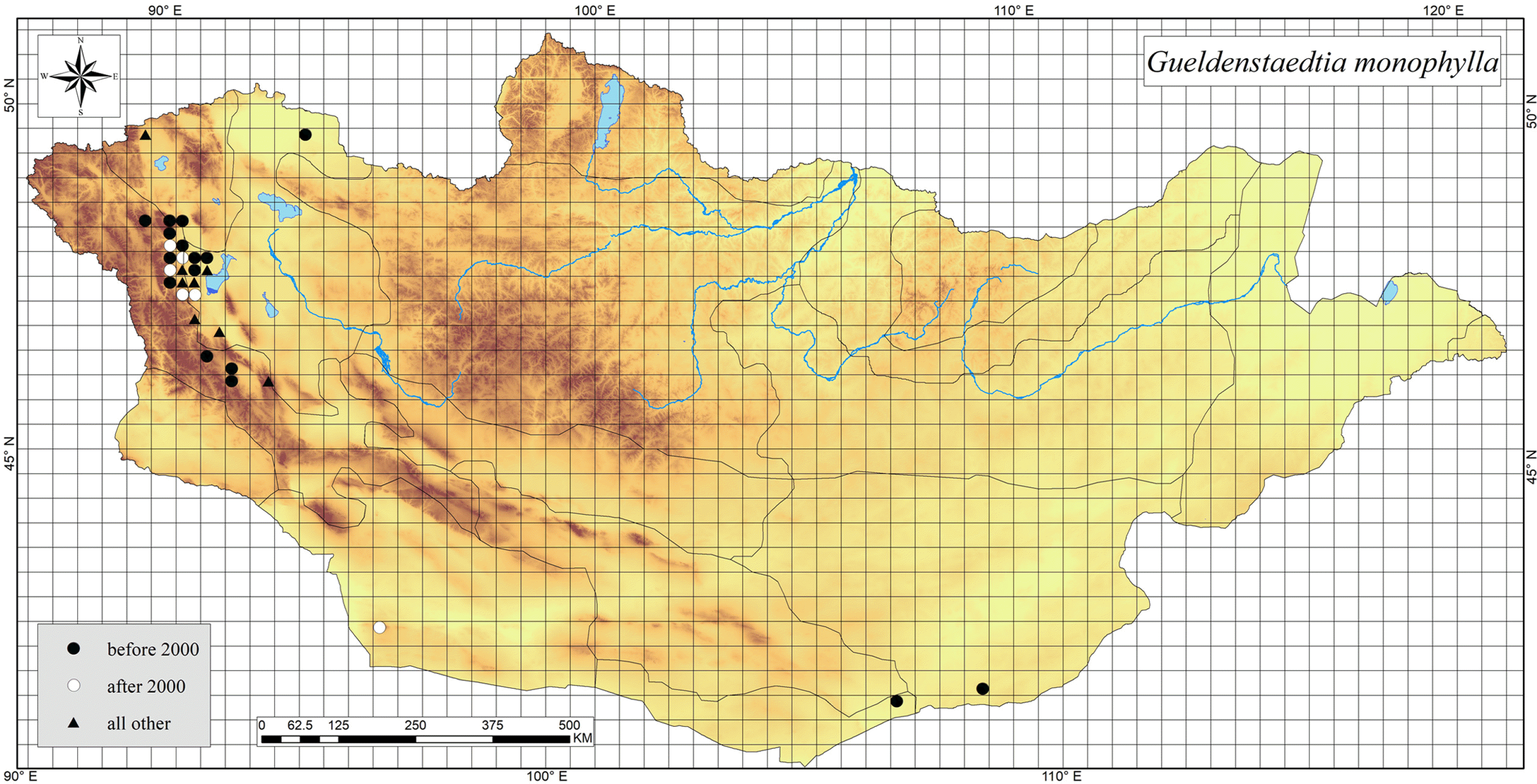
Note: In Mongolia, G. monophylla occurs in six phytogeographical regions (Selyutina 2021; Baasanmunkh et al., 2022a; Gundegmaa et al., 2022). Based on the grid map, we did not find any occurrences from the Gobi-Altai region (Fig. 2). Gueldenstaedtia monophylla grows on dry stony and debris slopes, rocks, and alkaline waterside pebbles (Grubov, 1982; Oyuntsetseg et al., 2017). In general, G. monophylla is quite widely distributed in the western Mongolia, but several isolated populations also occurs at low elevations in southern Gobi of the country (Fig. 2). This species is mostly grows on dry stone and debris slopes, rocks, and alkaline waterside pebbles at high (2,500 m) and low (780 m) altitude areas. According to Fig. 2, G. monophylla was recorded in low altitude area including three isolated populations in southern Gobi; however, this species is possible to be distributed across southern Gobi part due to limited field observations in Mongolia. According to ConR results, there were 17 unique occurrences in the country. The regional conservation status of G. monophylla was assessed as near threatened based on B criterion including EOO (107,721 km2) and AOO (12,800 km2) in Mongolia.
Specimens examined: MONGOLIA. Khovd region: Khovd province, Khovd sum, Ongontsnii Ulaan mountain, 48°16′55.2″N, 91°50′34.8″E, 1,500 m, a.s.l., 7 Jun 1976, W. Hilbig & Ts. Jamsran 43/74 (HAL46044); Khovd province, On the way to the Tavin Gasar from the Erdeneburen sum, 48°16′48″N, 91°33′10.8″E, 1,258 m a.s.l., 8 Jun 1976, W. Hilbig & Ts. Jamsran 53/74 (HAL41426); Khovd province, Khovd sum, Khajuu khutul, 48°4′15.6″N, 91°36′25.2″E, 1,530 m a.s.l., 16 Aug 1976, W. Hilbig & Ts. Jamsran (HAL48720); Khovd province, Buyant Sum, 48°0′7.2″N, 91°38′31.2″E, 1,230m a.s.l., 27 Jun 1982, E. Jager (HAL57860). Mongolian Altai region: Mountains near Shar-Nur lake, vicinity of Khovd town, 48°1′37.2″N, 91°21′32.4″E, 2,200 m a.s.l., 8 Aug 1898, E. N. Klements (LE); Steppe near Khovd town, 47°57′18″N, 91°24′7.2″E, 1,840 m a.s.l., 18 Jul 1906, V. V. Sapozhnikov (LE); Buyant river valley, 47°54′14.4″N, 91°17′13.2″E, 2,210 m a.s.l., 28 Aug 1930, V. I. Baranov (LE); 40 km north of Khovd town, along road to Tsagaan Nuur sum, 48°7′58.8″N, 91°24′ 28.8″E, 1,900 m a.s.l., 7 Aug 1945, A. A. Yunatov (LE); Khovd town, gasoline station, 47°57′18″N, 91°29′27.6″E, 1,570 m a.s.l., 29 Jun 1971, V. I. Grubov & N. Ulziikhutag et al. (LE); 74 km north of Khovd town, socle plain, 48°36′50.4″N, 91°14′31.2″E; 1,400 m a.s.l., 4 Aug 1977, Z. V. Karamysheva et al. (LE); North bank of Bayan-Nur lake, 48°40′8.4″N, 90°34′22.8″E, 2,430 m a.s.l., 25 Jul; 60 km north west of Khovd town, Khagiin-Khush hill, 48°24′57.6″N, 91°9′18″E, 1,800 m a.s.l., 30 Jul 1979, Z. V. Karamysheva et al. (LE); Ulaan Ergiin gol valley, granite Muu Ulaan Tolgoi knoll, 46°45′43.2″N, 92°48′50.4″E, 2,100 m a.s.l., 12 Aug 1979, V. I. Grubov, A. Muldashev, Sh. Dariimaa (LE); Khovd province, Must sum, Ulaan Ereg river, 46°39′6.92″N, 92°49′23.3″E, 2,088 m a.s.l., 12 Aug 1979, I. A. Grubov et al. 1278 (MW0182959); Khovd province, 11 km north from Khovd sum, valley of the Buyant river, 47°51′20″N, 91°5′30″E; 1,530m a.s.l., 24 Jul 1984, G. N. Ogureeva 271 (MW0182964); Khovd province, 1 km southwest from Khovd sum, 47°59′5.63″N, 91°38′49.6″E; 1,419 m a.s.l., 25 Aug 1985, I. A. Grubov 2043 (MW0182963); Khovd province, Erdeneburen Sum, 48°15′N, 91°22′E, 2,500 m a.s.l., 20 Jul 2000, B. Neuffer & H. Hurka 10246 (OSBU); Khovd province, Erdeneburen Sum, northern slope of Mant mountain, northern part of the Khong river, 48°23′23.86″N, 91°11′29.81″E, 1,549 m a.s.l., 22 Jun 2002, A. Zemmrich (GFW); Khovd province, Munkhkhairkhan sum, 29 May 2016, B. Oyuntsetseg (UBU). Depression of Great Lakes region: Uvs province, Tes sum, on the way to the Khar-Us lake from the Zuun lake, 50°18′32.22″N, 93°33′25.88″E, 779 m a.s.l., 23 Jul 1972, T. P. Nadezhina 171 (MW0182960); Khovd province, south from Khovd river, Ulaan Uul mountain, 48°41′56.4″N, 91°21′7.2″E, 1,200 m a.s.l., 7 Jun 1974, Ts. Jamsran & W. Hilbig (UBU0009741); Khovd province, Khovd city, 48°1′12″N, 91°41′49.2″E, 2,025 m a.s.l., 3 Jul 1974, Ts. Jamsran & W. Hilbig (UBU0009742); Khovd province, Khajuu khutul, 48°9′18″N, 91°16′1.2″E, 2,000 m a.s.l., 16 Aug 1976, Ts. Jamsran et al. (UBU0009744); Khovd province, Must sum, Ulaan mountain, 46°52′37.2″N, 92°17′34.8″E, 3,300 m a.s.l., 12 Aug 1979, N. Byambasuren (UBU0009740); Khovd province, Khovd sum, Ongontsnii Ulaan mountain, 48°16′33.6″N, 91°46′30″E, 1,580 m a.s.l., 15 Jun 1985, Sumya (UBU0009739); Khovd province, Buyant sum, on the way from Khovd to Myangad sum, 48°11′10.01″N, 91°48′26.91″E, 1,232 m a.s.l., 13 Jun 2002, A. Zemmrich AZ114 (GFW039244). East Gobi region: Ikh Shar Khid limestone massif, near Tenger Nuur lake, 100 km south west of Khatan-Bulag sum, 42°36′46.8″N, 108°28′44.4″E, 1,100 m a.s.l., 23 Jul 1974, E. I. Rachkovskaya & E. A Volkova (LE). Transaltai Gobi region: Govi-Altai province, Tsogt sum, Arts Bogd mountain, 43°23′21″N, 96°24′41″E, 1,600 m a.s.l., 5 Jul 2005, W. Hilbig (HAL131081). Alashan Gobi region: Umnugovi province, Tarvagat sum, Aguit mountain, 42°36′25.2″N, 107°49′19.2″E, 1,250 m a.s.l., 23 Jun 1980, I. A. Grubov 5615 (MW0182961).
Gueldenstaedtia verna (Georgi) Boriss. Spisok Rast. Gerb. Fl. S.S.S.R. 12: 122, 1953 (Figs. 4, 5); Astragalus vernus Georgi Bemerk. Reise Russ. Reich 1: 222, 1775.––TYPE: RUSSIA. Siberia, Georgi (lectotype: designed by Yakovlev (1980: 106), LE, Georgi’s specimen has not been preserved in LE).
Geuldenstaedtia stenophylla Bunge, Mém. Sav. Etrang. Scad. Sci. St. Peterb. 2: 98, 1833.–– TYPE: CHINA. Bor. Bunge s.n. (lectotype: LE, designated by Imkhanitskaya (2010: 194); syntypes: LE).
Perennial herb. Roots thick and woody, cylindrical. Stem almost absent, with persistent stipules. Plants with appressed hairs or glabrous. Leaves imparipinnate, 2–23 cm long, young leaves with long hairs, mature leaves with sparse appressed hairs or glabrous, petiole sulcate, slender, with white appressed hairs, leaflets 2–10 pairs, elliptical to lanceolate, ovate to widely ovate, apical leaflet sometimes obovate, ovate to elliptic, widely elliptic to widely obovate, blunt and apiculate at apex, sometimes young leaflets ovate and mature leaflets linear, 2–4.5 cm long, 1–10 mm wide, apiculate, acute, blunt, emarginated or retuse, pubescent or sometimes glabrous on both surfaces, rounded at base. Racemes with 2–8 flowers, peduncle sulcate, hairy, slightly longer than leaves before blooming, much longer than leaves after blooming. Pedicel slender, sulcate, 1–3 mm long, bracts triangular-linear, narrowly triangular, lanceolate, subulate, 2–4 mm long, bracteoles linear, 1/2 as long as calyx. Calyx campanulate, 5– 8 mm long, with long appressed white hairs, 5-lobed, lanceolate, upper 2 lobes equal to calyx, low 3 lobes shorter than calyx. Corolla violet, purple, and pink, standard ovate or sub-round, ovate, widely ovate or obovate, 9–13.5 mm long, 4.5–8 mm wide, emarginated at apex, tapering to claw at base; wings oblique obovate, 6–11 mm long, 1.7–3.5 mm wide, claw linear, 1.8–2 mm long, auriculate; keel-petals 4.2–7 mm long, 1–2 mm wide, oblique obovate, ovate, obovate, acuminate at apex, claw linear, 1.8–2.5 mm long; ovary tubular, cylindrical, oblong, elliptic, with densely appressed hairs, style glabrous, incurved, stigma round. Pods cylindrical, narrowly ovate, tubular, unilocular, 1.2–2 cm long, diameter 3–4 mm, with long hairs, when mature dehiscent along both sutures, with many seeds; seeds reniform or cylindric-reniform or triangular-reniform, with mark.
Flowering and fruiting: May to September.
Distribution: China, Korea, Mongolia and Russia (Zhu, 2004).
Note: Gueldenstaedtia verna is distributed in China, Mongolia, Russia, and South Korea (Zhu 2004; Jang et al., 2020). South Korean populations of this species are known from Daegu and its adjacent regions, which flowering time is March to April (Lee and Kim 2017; Jang et al., 2020). In Mongolia, G. verna is recorded in the northern and eastern parts including the Khuvsgul, Khentei, Middle Khalkh, and East Mongolia regions (Fig. 4). Gueldenstaedtia verna, between 800–1200 m, grows on sandy, debris and stony steppe slopes, steppe abandoned fields, and sandy places in Mongolia (Grubov, 1982). During our field surveys, we found it from the typical steppe area with very few populations. Based on ConR results, there were nine unique occurrences in the country. The regional conservation status of G. verna was assessed as near threatened based on B criterion including EOO (66,446 km2) and AOO (12,800 km2) in Mongolia. In general, G. verna is very variable in morphology and has a wide north-south distribution (Zhu, 2005). However, several accepted species, slightly difference of leaf shape and flower size, have been treated into G. verna due to pollen morphology (Zhu, 2004).
Specimens examined: MONGOLIA. Khuvsgul region: Selenge province, Tushig sum, 27 km west south from Tushig village, right bank of Zelter river, 50°13′1.2″N, 104°49′1.2″E, 807 m a.s.l., 23 Jun 2012, V. I. Ivleva (NSK). Mongolian Dauria region: Dornod province, 25 km north west from Bayan-Uul sum, south west macroslope Ereen davaa, Dalai amin river, 49°17′24″N, 112°28′26.4″E, 1,000 m a.s.l., 2 Aug 1990, I. A. Gubanov et al. 514 (MW0182970); Khentii province, Dadal sum, 49°16′22.8″N, 112°6′43.2″E, 1,100 m a.s.l., 10 Aug 1990, I. A. Gubanov & Sh. Dariimaa 718 (MW0182968); Khentii province, 17 km east from Dadal sum, Ereen davaa, Onon river, 49°5′9.6″N, 111°49′26.4″E, 900 m a.s.l., 12 Aug 1990, R. V. Kamilen et al. 777 (MW0182969); Selenge province, Khuder sum, Khuder river valley 5 km above Khuder village, 49°44′49.2″N, 107°26′24″E, 1,200 m a.s.l., 24 Aug 1990, R. V. Kamilen et al. 982 (MW0182971); Khentii province, Norivlon sum, 48°30′32.4″N, 111°47′6″E, 1,100 m a.s.l., 3 Jun 2020, Kh. Khaliunaa (UBU). East Mongolia region: Dornod province, 25 km east from Matad sum, 46°49′58.8″N, 115°30′0″E, 800–850 m a.s.l., 22 Jun 1987, R. V. Kamilen et al. 163 (MW0182967); Dornod province, 10 km south west from Baruun sul, Built mountain, 46°21′7.2″N, 116°33′7.2″E, 930 m a.s.l., 1 Aug 1991, R. V. Kamilen et al. 858 (MW0182966).